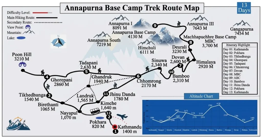
The Annapurna Base Camp trek map follows a scenic mountain route from the foothills near Pokhara into the Annapurna Sanctuary, ending at Annapurna Base Camp (4,130 m). The trail passes through traditional villages, lush forests, the Modi Khola valley, and high mountain landscapes surrounded by peaks such as Annapurna I and Machhapuchhre.
Depending on your itinerary, the Annapurna Base Camp trek can start from Nayapul, Kimche, or another road-access point near Pokhara and usually takes 7-12 days. Popular routes pass through places such as Ghandruk, Chhomrong, Sinuwa, Bamboo, Dovan, Himalaya, Deurali, Machhapuchhre Base Camp, and finally Annapurna Base Camp.
The total walking distance varies by starting point and route, but most itineraries cover approximately 70-115 km round trip. If you add Poon Hill, the route becomes longer and typically takes more days.
In this guide, you’ll find the Annapurna Base Camp Trek route map, starting points, day-by-day trail, walking distances, major stops, elevation changes, and route options to help you understand exactly what to expect before starting the trek.
At a Glance: The ABC Trek Route
- Round-trip distance: 70-115 km, depending on route
- Duration: 7-12 days, 5-7 hrs walking per day
- Two route options: Ghorepani/Poon Hill (longer) or Ghandruk (shorter)
- Both routes converge at Chhomrong, then follow the same trail to ABC
- Max altitude: 4,130 m, lower and less demanding than EBC (5,364 m)
- One ACAP permit covers the whole trek, no extra fees
- The Annapurna Base Camp trail is well-marked and teahouse-supported end to end
- Manageable for reasonably fit beginners with proper acclimatization
Understanding the Annapurna Base Camp Trek Route
The Annapurna Base Camp trek route follows the Modi Khola river gorge north from the mid-hills into the high mountains. Unlike circuit treks that loop around a massif, ABC is an out-and-back trek. You walk up one valley to the base camp and largely retrace your steps on the way down, sometimes via a slightly different lower-village combination.
The trail passes through a genuine cross-section of the Annapurna region: terraced farmland and Gurung and Magar villages in the lower hills, dense rhododendron and bamboo forest through the middle section, and finally the stark glacial terrain of the Annapurna Sanctuary itself. Every stop on the map corresponds to a real elevation and ecological shift, which is part of what makes the route feel so varied for a trek that rarely exceeds two weeks.
Annapurna Base Camp Trek Route Options: Ghandruk or Ghorepani
Trekkers generally choose between two approaches to reach Chhomrong, the village where both routes converge:
- Classic route via Ghorepani and Poon Hill: Starts at Nayapul, climbs through Tikhedhunga and Ulleri to Ghorepani, detours up to the Poon Hill viewpoint for sunrise over the Annapurna and Dhaulagiri ranges, then continues through Tadapani to Chhomrong. This is the longer option, adding roughly one to two extra days and around 40 km compared to the direct route.
- Direct route via Ghandruk: Starts at Nayapul or Kimche, heads more directly to Landruk and the well-known Gurung village of Ghandruk, then joins the main trail at Chhomrong. This route is shorter and involves less elevation gain in the early stages, making it a common choice for trekkers with limited time.
From Chhomrong onward, both routes follow the same path: Chhomrong → Sinuwa → Bamboo → Dovan → Himalaya → Deurali → Machhapuchhre Base Camp (MBC) → Annapurna Base Camp (ABC).
Annapurna Base Camp Trek Map: Major Stops
The Annapurna Base Camp trek map follows from Pokhara to the end with Annapurna Base Camp. The major stop started from Nayapul to Annapurna Base Camp.
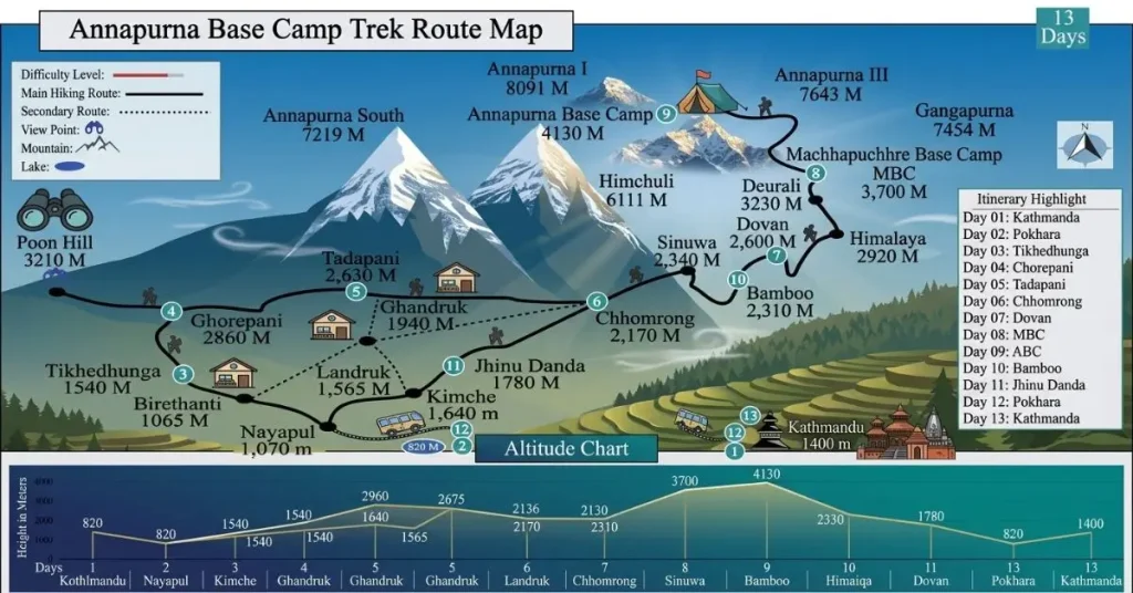
| Stop | Approx. Altitude | District | Notes |
|---|---|---|---|
| Nayapul | 1,070 m | Kaski | Common road-end starting point |
| Kimche | 1,640 m | Kaski | Alternative starting point, shortens the walk-in |
| Ghandruk | 1,940 m | Kaski | Large Gurung village, museum, Annapurna views |
| Landruk | 1,565 m | Kaski | Village stop on the direct route |
| Tadapani | 2,630 m | Kaski | Forest viewpoint connecting the two route variants |
| Ghorepani | 2,860 m | Myagdi | Base for the Poon Hill sunrise detour |
| Poon Hill | 3,210 m | Myagdi | Panoramic viewpoint, optional detour |
| Chhomrong | 2,170 m | Kaski | Route convergence point, last large village |
| Sinuwa | 2,340 m | Kaski | Forest transition begins |
| Bamboo | 2,310 m | Kaski | Named for dense bamboo groves |
| Dovan | 2,600 m | Kaski | Narrow gorge section |
| Himalaya | 2,920 m | Kaski | Last forested stop |
| Deurali | 3,230 m | Kaski | Landslide-prone narrow section above camp |
| Machhapuchhre Base Camp (MBC) | 3,700 m | Kaski | Closest teahouse stop to Machhapuchhre |
| Annapurna Base Camp (ABC) | 4,130 m | Kaski | Final destination, inside the Annapurna Sanctuary |
The Map of Annapurna Base Camp Trek also shows Jhinu Danda, which is not on the ascent route but is a popular stop on the way down for trekkers who want to soak tired legs before returning to Nayapul.
Annapurna Base Camp Trek Starting Point
The Annapurna Base Camp trek starting point is Nayapul, a roadhead village about a 1.5-2 hour drive from Pokhara. Nayapul is where most itineraries officially begin walking, whether you’re heading toward Ghandruk or Ulleri.
Some itineraries instead drive a little further to Kimche or Siwai, cutting out an early, relatively flat stretch of trail and shaving a few hours off the first day. This does not change the rest of the route. It simply moves the starting point slightly closer to Ghandruk.
| Good to Know: Pokhara itself is not the starting point of the trek. It is the transit hub. Every itinerary begins with a drive from Pokhara to Nayapul or Kimche before the walking starts. |
Annapurna Base Camp Trek Distance
Reported distances for the ABC trek vary across sources because the total depends heavily on which route variant you take and where your itinerary starts and ends. As a practical baseline:
| Route Variant | Approx. Round-Trip Distance | Typical Duration |
|---|---|---|
| Short route via Ghandruk (no Poon Hill) | ~70 km | 7-9 days |
| Standard route with partial Poon Hill loop | ~90-100 km | 9-10 days |
| Classic route via full Poon Hill loop | ~110-115 km | 10-12 days |
Daily walking distances on the ABC trek typically run 7 to 15 km, covered in 5 to 7 hours, with the terrain, including stone staircases, suspension bridges, and steady elevation gain, mattering more for pacing than raw distance. The final push from Deurali to ABC and back is usually the shortest daily distance but the most physically demanding due to altitude.
Responsible Trekking on the ABC Route
The Annapurna Conservation Area is Nepal’s largest protected area, and the ACAP fee directly funds trail maintenance, ranger posts, and community development in the villages you pass through. A few practical ways to trek responsibly along this route:
- Carry out non-biodegradable waste rather than relying on village disposal.
- Buy meals, snacks, and hot showers directly from teahouses along the route to support local Gurung and Magar communities.
- Stick to marked trails, particularly in the Deurali-MBC section, to avoid disturbing fragile alpine terrain.
- Ask before photographing lodge owners or villagers, especially in smaller settlements like Ghandruk.
Why Use Wander Himalayan for Nepal Trekking Information?
Wander Himalayan exists to help you understand and plan your trek, not to sell you one. As an independent Nepal travel information platform, the site focuses purely on giving trekkers accurate, practical, and locally informed content so you can make your own decisions with confidence.
- Independent and unbiased. Wander Himalayan does not operate tours or sell trekking packages, so route recommendations and difficulty ratings are not shaped by sales incentives.
- Practical, planning-focused detail. Coverage goes beyond inspiration to the things that actually matter for planning: distances, altitudes, permit costs, starting points, and seasonal conditions.
- Up-to-date information. Trekking regulations, permit fees, and route conditions in Nepal change often, and the content reflects current rules rather than outdated blog posts.
- Broad regional coverage. From Annapurna and Everest to Langtang, Manaslu, and Mustang, the site helps you compare regions and routes before committing to one.
- No booking pressure. There is no push to purchase a package or commit to an operator. The goal is simply a clear, accurate picture of what a trek involves.
- A resource for every stage of planning. Whether you are deciding between routes, checking permit requirements, or figuring out a starting point, the content is built to answer that specific question.
Final Thoughts
Understanding the Annapurna Base Camp trek map comes down to understanding one valley, the Modi Khola, climbed from the mid-hills near Pokhara into the natural amphitheater of peaks surrounding Annapurna I. Whichever route you choose, whether the classic path via Ghorepani and Poon Hill or the shorter approach through Ghandruk, both converge at Chhomrong and follow the same forested trail up to Annapurna Base Camp at 4,130 m.
With the route, distances, and permit requirements laid out here, you should have a clear picture of what the trek involves before committing to an itinerary.
Frequently Asked Questions
1. Can a beginner trek to Annapurna Base Camp?
Yes, a beginner can trek to Annapurna Base Camp with reasonable preparation. The trail doesn’t require technical skills, teahouses are available the entire way, and a slow, steady pace with proper acclimatization makes it manageable for first-time trekkers.
2. Is ABC harder than EBC?
ABC is generally considered less difficult than EBC, mainly because it tops out at a lower altitude (4,130 m versus 5,364 m) and takes fewer days overall, reducing prolonged exposure to thin air.
3. How difficult is Annapurna Base Camp?
Annapurna Base Camp is a moderate-difficulty trek involving daily elevation changes, stone staircases, and altitude above 3,500 m for the final stretch, achievable by most reasonably fit trekkers with preparation.
4. Is Annapurna Base Camp risky?
Annapurna Base Camp carries typical high-altitude trekking risks, including altitude sickness, weather changes, and landslide-prone sections near Deurali, that are manageable with proper acclimatization but not eliminable entirely.
5. Can normal people go to Annapurna Base Camp?
Yes, normal people without mountaineering experience go to Annapurna Base Camp every season, since the route is teahouse-supported and doesn’t require climbing gear or technical training.
6. Where does the Annapurna Base Camp trek start?
The Annapurna Base Camp trek starts at Nayapul, a village roughly 1.5-2 hours by road from Pokhara, though some itineraries drive slightly further to Kimche or Siwai to shorten the first walking day.
7. How long is the Annapurna Base Camp trek map route?
The total round-trip distance ranges from about 70 km on the shorter Ghandruk route to around 115 km on the classic route that includes the Poon Hill detour.
8. Do I need a guide for the Annapurna Base Camp trek?
Yes. Under regulations introduced by the Nepal Tourism Board (NTB) and the National Trust for Nature Conservation (NTNC), all foreign trekkers in the Annapurna Conservation Area are required to hire a licensed guide through a registered trekking agency. Independent solo trekking without a licensed guide is no longer permitted on this route.
9. What is the highest point on the Annapurna Base Camp trek map?
Annapurna Base Camp itself, at 4,130 m, is the highest point most trekkers reach, though the optional Poon Hill detour adds a secondary viewpoint at 3,210 m earlier in the route.
10. Can I do the Annapurna Base Camp trek without Poon Hill?
Yes, you can do the Annapurna Base Camp trek without Poon Hill, as the direct route via Kimche, Landruk, and Ghandruk skips Poon Hill entirely and rejoins the main trail at Chhomrong, shortening the trek by roughly one to two days.
11. What permits appear on the ABC trek map’s checkpoints?
The Annapurna Conservation Area Permit (ACAP) is the primary entry permit verified at major checkpoints like Birethanti, Chhomrong, and Jhinu Danda. Checkpoints also inspect guide credentials and registered agency documentation (or TIMS registration details) to ensure compliance with Nepal’s safety and trekking regulatio
Sources:
NTNC e-Permit Portal: https://epermit.ntnc.org.np/
Sandeep Poudel is the founder of Wander Himalayan and a lifelong traveler with a deep interest in Nepal’s mountains, culture, landscapes, and local communities. His interest in exploring Nepal began early in life and has grown into a passion for discovering places beyond the usual tourist routes and understanding what makes each destination unique.
From detailed trekking guides and packing advice to destination guides, travel costs, transportation, and local insights, Sandeep focuses on information that travelers can actually use when planning a trip.